
Morocco is preparing for the impacts of the Atlantic storm “Claudia,” which is considered one of the most significant weather phenomena of this week. Named by the Spanish Meteorological Agency, its effects will be indirect, featuring heavy rainfall and stormy winds.
### Formation and Path of the Storm
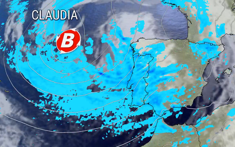
Storm “Claudia” formed over the Atlantic Ocean, west of the Iberian Peninsula, as a deep low pressure system fueled by conflicting cold and warm air flows. According to Morocco’s General Directorate of Meteorology, the storm’s effects are expected to begin affecting Morocco starting Wednesday, with heavy cloud cover and gradual rainfall over the central plains. Unstable conditions will persist throughout Friday and Saturday, with a gradual return to stability by next Wednesday, indicating a relatively short but intense transitional period.
The storm is expected to reach within 37 hours of the Moroccan coasts, making the north and central regions the most susceptible to low atmospheric pressure.
### Expected Effects on Morocco: Between Benefit and Challenge
The primary impacts of “Claudia” will be concentrated in the northern and central regions of the kingdom, affecting areas such as Tangier, the Rif, northern coasts, the High and Middle Atlas, Atlantic plains, Souss, the eastern region, and the northern desert provinces.
Forecasts indicate that rainfall amounts will be heavy, with local thunderstorms expected in Tangier and the Rif, and scattered light rain along central coasts and in Saiss. Although exact amounts have not been specified, experts describe the rainfall as “significant,” potentially exceeding 50 mm in some mountainous areas, which could replenish dams and water reserves after weeks of drought.
Winds are expected to be relatively strong, reaching speeds that may trigger gusts during thunderstorms in the southern Atlas and inland areas of Souss, with the possibility of local dust storms in the southeastern regions and desert provinces.
### Canary Islands Close Schools
The Canary Islands, which are beginning to feel the effects of the storm, have decided to suspend classes across the archipelago on Thursday due to the arrival of Storm Claudia, which is bringing heavy rain and strong winds of up to 90 km/h.
This decision was made based on recommendations from the General Directorate of Emergencies and Civil Protection, aiming to avoid travel and prevent incidents in light of the expected severe weather conditions in the coming hours within the islands, which are under heightened alert due to ongoing rain and strong winds.
### Notification from Moroccan Meteorology
It is noteworthy that the General Directorate of Meteorology issued an advisory bulletin without naming “Storm Claudia,” instead mentioning locally strong wind gusts and dust storms (ranging from 70 to 90 km/h) affecting the provinces of Boulemane, Kserif, Taourirt, Jerada, Figuig, Oujda Angad, Berkane, Nador, Midelt, and Sefrou, starting Wednesday at 3 PM until Thursday at 11 PM.
The source added that locally strong wind gusts and dust storms (ranging from 70 to 85 km/h) are expected in the provinces of El Rahamna, El Jadida, Safi, Sidi Bennour, Youssoufia, Chichaoua, Essaouira, Mohammedia, Marrakech, Casablanca, Mediouna, Nouaceur, Rabat, Salé, Temara, Benslimane, Berrechid, Settat, Khouribga, and Khemisset, starting Thursday from 6 AM to 11 PM.
Additionally, the General Directorate of Meteorology expects thunderstorms with local gusty winds (ranging from 25 to 50 mm) in the provinces of Taroudant, Agadir-Ida Ou Tanane, Al Haouz, Chichaoua, and Essaouira, starting Wednesday at 9 PM until Thursday at 9 PM.
Source